


New Zealand: A Caravan Experience
Written By: SUSANNE LOMATCH
PAGE 5....
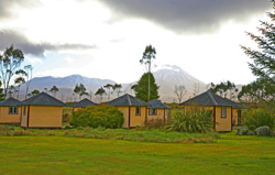 The Discovery Lodge is the closest caravan park to the entrance, so we settled there for
the eve. The night was very cold – into the upper 20s/low 30s. Thank goodness for the
caravan heat pump! We were the only, the lonely, campers that day. A rare gift bestowed,
the clear, dark night sky revealed both the large and small Magellanic Clouds, two
spectacles of the southern sky. We had never seen them so bright and prominent.
Morning sun and fog – we could barely make out the local
volcanoes Ngauruhoe and Ruapehu. But one other feature caught our attention in the
fields adjacent – Frisbee golf traps! Our curiosity landed us with a staff member and local
champion lending his golf bag of discs, and a revelation that this had been the national
championship site last summer. We’re not avid Frisbee golfers – but we play when we
get the chance, and with the suspended fog at a few hundred feet we thought we’d whittle
the burn off time to play a few holes.
The Discovery Lodge is the closest caravan park to the entrance, so we settled there for
the eve. The night was very cold – into the upper 20s/low 30s. Thank goodness for the
caravan heat pump! We were the only, the lonely, campers that day. A rare gift bestowed,
the clear, dark night sky revealed both the large and small Magellanic Clouds, two
spectacles of the southern sky. We had never seen them so bright and prominent.
Morning sun and fog – we could barely make out the local
volcanoes Ngauruhoe and Ruapehu. But one other feature caught our attention in the
fields adjacent – Frisbee golf traps! Our curiosity landed us with a staff member and local
champion lending his golf bag of discs, and a revelation that this had been the national
championship site last summer. We’re not avid Frisbee golfers – but we play when we
get the chance, and with the suspended fog at a few hundred feet we thought we’d whittle
the burn off time to play a few holes.
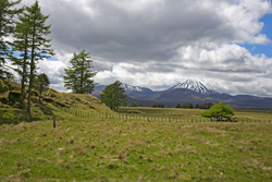 As we played, Ngauruhoe came into full view. The
terrain was challenging, but not the hardest course we’d played – that belongs to Bogus
Basin Idaho, with its steep slopes and dense brush. Nine holes (we’ll do the full 18 next
time), and it was time to check out and head up the road to the north slope of Ruapehu,
and the Whakapapa ski area.
As we played, Ngauruhoe came into full view. The
terrain was challenging, but not the hardest course we’d played – that belongs to Bogus
Basin Idaho, with its steep slopes and dense brush. Nine holes (we’ll do the full 18 next
time), and it was time to check out and head up the road to the north slope of Ruapehu,
and the Whakapapa ski area.
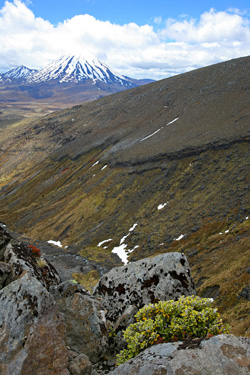 We didn’t know what to expect at Whakapapa – the area was closed for season skiing,
but the road up to the 1630m (5500ft) base was dry and scenic. The café was open, and
the snowfields melting but still covering the dark volcanic slopes. We decided to hike the corn snow up
to a ridge, where we might see Ngauruhoe and the Alpine Crossing. Granted another
gift, the scenery was breathtaking. Ngauruhoe framed by the rocky, sometimes vertical
slopes of Ruapehu. Ngauruhoe is better known as "Mt. Doom" of Mordor from the Lord
of the Rings (LOTR) film trilogy, and with difficulty is pronounced "na uru hoe,"
meaning "throwing heated stones" in Maori (indigenous native NZ’ers and their
vernacular). As we lingered at our earned view we watched a young band of rock
climbers heading in our direction – intent on climbing down the vertical rock face toward
the valley peak below.
We didn’t know what to expect at Whakapapa – the area was closed for season skiing,
but the road up to the 1630m (5500ft) base was dry and scenic. The café was open, and
the snowfields melting but still covering the dark volcanic slopes. We decided to hike the corn snow up
to a ridge, where we might see Ngauruhoe and the Alpine Crossing. Granted another
gift, the scenery was breathtaking. Ngauruhoe framed by the rocky, sometimes vertical
slopes of Ruapehu. Ngauruhoe is better known as "Mt. Doom" of Mordor from the Lord
of the Rings (LOTR) film trilogy, and with difficulty is pronounced "na uru hoe,"
meaning "throwing heated stones" in Maori (indigenous native NZ’ers and their
vernacular). As we lingered at our earned view we watched a young band of rock
climbers heading in our direction – intent on climbing down the vertical rock face toward
the valley peak below.
 Wanting desperately to stay another night in the area and to ski the
south slope (Turoa – still open, and 30 mins. away), we called the local ski report – and
got bad news of more inclement weather and a closure of the area for the next day.
Though disappointing, as we wanted to add NZ skiing to our badge, the mid-spring ski
conditions would likely have been hard chunky crud and ice unless we chose groomers.
Not having your own ski gear is also a compromise.
Wanting desperately to stay another night in the area and to ski the
south slope (Turoa – still open, and 30 mins. away), we called the local ski report – and
got bad news of more inclement weather and a closure of the area for the next day.
Though disappointing, as we wanted to add NZ skiing to our badge, the mid-spring ski
conditions would likely have been hard chunky crud and ice unless we chose groomers.
Not having your own ski gear is also a compromise.
A quick decision had us on the road back toward Taupo, intent on catching the wine road at Hawkes Bay.
The drive was long, and we almost ran out of diesel. On some routes there is a scarcity of petrol stations,
and a lack of signs advising travelers of that fact! Always keep your tank filled when possible.
Taupo is a temperate, semi-arid lake area, flat for the most part. But the drive to the coast and Hawkes
Bay on R5 was filled with steep rolling hills and a rainforest reminiscent of Hawaii. NZ has microclimates,
just like the Big Island, except many more of them. Taupo-Tongariro Photography.